San Ramón Fault: the threat the authorities don't want to see
In recent weeks, new information has emerged regarding the fault system located to the east of the central depression: The San Ramón Fault exists, is active, and runs through the Andean piedmont.
During the 1980s, the expansion of the city of Santiago forgot all understanding of its own territory. In 1974, urban land was declared a "limitless resource," and the neoliberal city was conceived as an entity disconnected from the geological, environmental, hydrological, and other dynamics that support life downstream. In the end, the city expanded into the Andes without prior studies and disregarded the concerns raised by neighbors. Today this information is coming to light: forests generate water and are an important part of the hydrological cycle; forests clean and cool the air that descends from the mountains every afternoon; forests mitigate the impacts of landslides, floods, and mass movements. What we did not know was that hidden beneath the precordilleran forests lay a latent threat: the San Ramón Fault.
In recent weeks, new information has emerged regarding the fault system located to the east of the central depression: The San Ramón Fault exists, is active, and runs through the Andean piedmont.
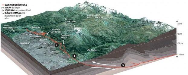
Faults are discontinuities in the Earth's crust that can shift along a favorable plane and, through internal pressure, are capable of releasing energy at any moment. In Chile, the fault system located to the east of the central depression is related to the formation of the Andes through the convergence of the Nazca and South American plates. Of this system, the San Ramón Fault stands out due to its high risk to the population living above it, as it is a reverse fault. This means it is "a geological structure [...] in which the Main Andes range rises relative to the Santiago valley." (Rodrigo Rauld (2016), Falla de San Ramón. Retrieved from https://sociedadgeologica.cl/falla-san-ramon/)
(Image source: Cristián Pacheco (2014), Advierten impacto de urbanización en falla geológica San Ramón, Santiago de Chile. Retrieved from http://olca.cl/articulo/nota.php?id=104190)
Does being unpredictable mean it can't be anticipated?
Being unpredictable does not mean it cannot be prevented. On this, both the State and society are falling short (let us recall the 1993 landslide in Santiago, the 2015 landslides in the north, the 2011 Chaitén volcanic eruption, the 2017 landslide at Villa Santa Lucia, the 2010 earthquake and tsunami, and countless other events). In fact, the essence of risk studies is to understand and coexist with the dynamics of the Earth's living system, to understand these dynamics and organize ourselves in such a way as to receive the least possible impact. Likewise, the objective of Territorial Planning and Land Use instruments — whether Municipal Zoning Plans (PRC), Regional Regulatory Plans, Sectional Plans, etc. — is to give a harmonious and coexistence-oriented sense to land use, including risks (threat and vulnerability in a territory), urbanization, conservation, green areas, and so on. The State, through policies, generates plans and strategies to carry them out. However, over the years we have seen the lack of prevention in the policies that have been implemented. For example, the 1974 National Urban Development Policy declares urban land a non-scarce resource; the Metropolitan Regulatory Plan of Santiago (PRMS) in 1994 raises the urban limit to the 1,000-meter contour line; the precordillera begins to be depleted, eliminating all the beneficial factors mentioned above.
In 2012, the Ministry of Housing and Urban Planning (MINVU) published a study on the San Ramón Fault. This study declared that the fault does exist and is active, but that its recurrence interval was so long (every 7,000 years) that it did not warrant much attention. However, more recent studies contrast with the government's optimistic, pro-urbanization view, as they indicate that the fault is a current threat and that we are within the time range in which it could be activated, making it a real danger especially for families living above it.
Meanwhile, the study on the fault and its latest conclusions have not been taken into account, nor have they been incorporated into the Territorial Planning instruments, much less into municipal or metropolitan regulatory plans. We watch in astonishment as projects continue to be developed and construction permits continue to be approved above it. The city advances blindly: medium-term death traps rising above forests and ravines.
What happened with this fault that was not considered, and today thousands of families live in high-risk zones? What happens with the forests that protect us from mass movements, earthquakes, and are an important part of the hydrological cycle — forests that are not protected? Do we wait for a new tragedy to occur before we correct the decisions of a few on matters that concern us all? The San Ramón Fault is today becoming more real; studies verify this increasingly, despite the fact that neighbors raised the alarm and no one listened — and today they are being proven right. Is the city built to generate profits and political favors for big business, over the lives of the communities that inhabit it?
There is still territory to defend and care for, and in doing so we also protect ourselves.
We call on the State and its authorities to be responsible, to incorporate this knowledge into territorial planning instruments, and to definitively protect these areas, creating, for example, a great National Park throughout the entire precordillera and Andes range of Santiago.
The content expressed in this article is the responsibility of its original authors and does not necessarily represent the views associated with the Panul Para Todos project.
The information archived in Archivo Panul was collected using automated tools, so there may be inconsistencies between what is presented here and the original link. You can visit the original link at the top of this article.