The Quebrada de Macul Landslide: Natural disaster or planned crime?
This May 3 marks 20 years since the Quebrada de Macul Landslide — a date etched in the historical memory of all, which leads us to remember, reflect, but also draw lessons and hold those responsible accountable so that it does not happen again.
"I believe that memory has the force of gravity — it always draws us. Those who have memory are capable of living in the fragile present. Those who do not, live nowhere."
(Patricio Guzmán in "Nostalgia de la Luz").
On May 3, 1993, the Quebrada de Macul landslide occurred. It is a date etched in the historical memory of Santiago and the country — 20 years have passed and this tragedy still leaves us with lessons. For some it is merely a display of nature occasionally reminding us of its power, but for others it represents a transcendental turning point in their lives — a watershed that clearly marks a before and an after.
The disaster mainly affected the precordilleran zone of La Florida and Peñalolén, leaving three settlements destroyed, more than 32,000 people displaced, and 23 dead. Accounts and information from the time describe it as an "unfortunate natural catastrophe" — yet given urban growth and unusual weather conditions, it seems logical to ask to what extent the negative consequences of these events are avoidable. By all accounts it should be a priority of the authorities to take the necessary measures to minimize the effects of an ever-latent risk — but despite warnings and proposals from residents and community organizations, they do very little, and what they do, they do very badly.
What is sometimes hidden behind the label of natural catastrophe, in the case of Santiago's precordillera, is straightforwardly the planning of a crime. With all the background information needed to identify the risks at hand, it is ignored — exposing the irresponsibility of the authorities and a shortsighted territorial development policy, which fails to incorporate the community's perspective and plans primarily on the basis of real estate profit, thereby endangering the safety and lives of the population that comes to live there and in the surrounding areas.
To learn more about the problems identified by the community, we went to speak with the president of the El Esfuerzo Neighborhood Association, Juan Alcaíno, who experienced the landslide nightmare firsthand and has a long history as a community leader. He kindly welcomed us into his home and showed us on the ground that, more than 20 years later, the authorities are still not doing their job properly (see photographs and chronology).
The way the Quebrada de Santa Sofía de Lo Cañas ends is truly extraordinary: a chamber on Avenida Canal Las Perdices, where the water is diverted northward through a rudimentary ditch that ends in a dead end (a hole). An unplanned work where water would flow down María Angélica or flood the adjacent land to the west.
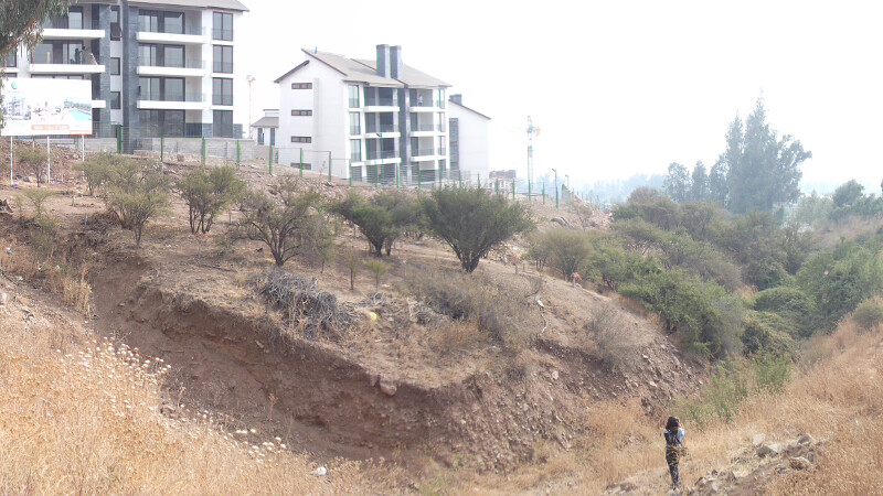
The construction of these buildings is dangerously close to the ravine. What might appear to be a dream view in a nature-surrounded setting conceals the serious danger to which its residents are exposed.
This speed bump does not respect the free flow of water and is a dangerous obstruction for the current, since it has edges and large material. This situation has been reported to the authorities on countless occasions.
Every year a large torrent of water flows down Calle María Angélica from Alto Macul, where the minimum spacing between sewage chambers is completely insufficient — and the construction company fails to meet the requirement of one every 50 meters.
Dirty, unmaintained ravines — all these elements impede the free circulation of water during the rainy season.
PLANNING TOMBS
With the arrival of the dictatorship to power, the current urban planning policy began to take shape — one that privileges mega-projects that increase centralization and poor quality of life in large cities. This misnamed planning builds chaos and generates juicy private profits through the banking credit system and market speculation, creating false growth projections and irrationally stimulating housing demand.
Thus, decentralization policies become failures — resulting in Santiago having expanded its urban area from 38,000 to 75,000 hectares in 30 years. In other words, in three decades we grew more than we had in 440 years of history.
CHRONOLOGY
1993: Quebrada de Macul Landslide. A 100-meter restriction zone is established on each side of the ravine. Not all housing within the area is evacuated, due to the high cost of relocation.
1994: Under the government of Eduardo Frei, the Santiago Metropolitan Zoning Plan is approved, which raises the urbanization contour (from 900 to 1,000 meters) and densities in the precordillera (from 25 to 650 residents/hectare).
1995: The company Macalto submits a mega-project for 8,000 houses and 150 residents/hectare adjacent to the southern side of the ravine.
1995: The Municipality of La Florida, with Gonzalo Duarte as mayor, approves the preliminary project and, following fierce resident pressure, rejects the construction permits. Macalto appeals to the Supreme Court.
1995: Residents mobilize and succeed in pushing through a sectoral plan to protect the precordillera.
1996: The municipality approves this sectoral plan, which reduces density to 25 and 50 residents/hectare. Macalto again goes to court.
1997, August: The Supreme Court rules in favor of the new sectoral plan.
1997, October: The Supreme Court upholds the real estate company's appeal and orders the municipality to approve the Macalto project, overriding the sectoral plan's guidelines — because the preliminary project had been approved before the plan. The murky approval of the preliminary project proved decisive.
2000: Under Pablo Zalaquett as mayor of La Florida, land subdivision in the precordillera is reduced from 2,000 to 1,000 m². Meanwhile, residents continue living in the exclusion zone.
2000: The Jardines de la Viña project is approved at the foot of another active ravine — Lo Cañas.
2002: New construction permits are granted for Macalto.
2008: The Municipal Council commits at a public hearing to amending the Municipal Zoning Plan (PRC) for the precordillera zone and preventing mega-projects there.
2008: Real estate company Gesterra submits a preliminary project for 1,300 housing units in Fundo Panul.
2011: The Municipality, under Rodolfo Carter, approves the real estate preliminary project in Fundo Panul.
2012: The organized community manages to stop the Panul project after 4 years of opposition.
2012: Historic citizen consultation in which 22,000 La Florida residents turn out to vote. 98% support protecting Panul and the precordillera.
2013: To date, the amendment to the Municipal Zoning Plan (PRC) for the precordillera has still not begun.
MEMORY AND TERRITORY: TWO SIDES OF THE SAME PRESENT
The commemoration of the 20th anniversary of the Quebrada de Macul Landslide carries a powerful emotional weight for those who lost family members and loved ones — they are the most intimate and profound dimension of memory.
However, this event is also part of our collective memory. Many precordillera residents began to organize following this historical event in order to participate in decisions about the territory they inhabit — through neighborhood associations and organizations like ours, Red por la Defensa de la Precordillera.
This date reminds us that Bosque Panul, among its many other functions within the ecological balance, is a natural protection for La Florida's residents against landslides in the area. Yet despite this importance and strategic relevance, it continues to be threatened by projects that seek to fell it and subsequently urbanize it.
AND WHERE IS THE STATE?
Urban planning over the past four decades not only fails to incorporate the imminent risks produced by nature — it builds while hiding this vital information, endangering the lives and safety of the population that comes to live there and in its surroundings.
On the other hand, the State suffers from amnesia: when a new authority takes office, they discard or completely forget previous agreements and commitments. Thus, the State evades its responsibility to protect the lives of the population by handing it over to private enterprise — which is more concerned with making a profit than with thoroughly evaluating risks, since this runs counter to its interests.
The inhabitants of the affected territory can never participate in these decisions, even though we are the ones who directly bear the consequences of this criminal construction policy.
Faced with this scenario, there is nothing left but to take the bull by the horns and fully exercise our sovereignty — proposing, together with all social actors, an urban planning built from the people. Taking responsibility for the territory through community-based management becomes essential, in the face of the State's inadequacy and incapacity, and the voracity of real estate capital. We are a living part of the place we inhabit, and it is our duty and our right to decide what happens to it.
This May 3, family members and neighborhood associations invite everyone to the Memorial Mass for the victims of the Quebrada de Macul Landslide, to be held at 8:00 p.m. at the CIQMA (former Capilla Santa Teresa).
ADDRESS: PUENTE MARÍA ANGÉLICA CON LAS PERDICES, LA FLORIDA. TIME: 8:00 p.m.
Red por la Defensa de la Precordillera, May 3, 2013.
The content expressed in this article is the responsibility of its original authors and does not necessarily represent the views associated with the Panul Para Todos project.
The information archived in Archivo Panul was collected using automated tools, so there may be inconsistencies between what is presented here and the original link. You can visit the original link at the top of this article.